Our Civilization Model:
To answer this important question, we chose to focus on two methods of agriculture practiced by the people of an area in Meso-America. This group of ancient people are known as the Central Lowland Maya, and specifically inhabited a region known as the Peten, which included parts of Guatemala, Belize, Mexico and Honduras. The Central Lowland Maya occupied this region in cosmopolitan city-states from approximately 300 BC - 1300 AD. [4] These city-states, for example Tikal, could have been populated by upwards of 45,000 people at any given time;[4] therefore, they had a great need for reliable methods of agriculture to work cohesively in the environment they inhabited for extended periods of use.
Purpose:
This website is intended to inform and guide visitors about agricultural methods in relation to their environments natural capacities. Modern agriculturalists will find the information useful when considering what agricultural methods to implement given the environment where they would be farming. Students researching and investigating about ancient civilizations or agricultural techniques would benefit from a historical perspective.
|
Why should agriculture be compatible with the environment?Understanding how our environment resists and responds to human activity better enables us to find manageable ways to work with the natural limitations as opposed to straining it and disabling its ability to thrive.
By using the Central Lowland Maya (from late classic to Terminal period) as a case study, we will provide information about the use of both agricultural methods in the long-term, in order to compare their disparaging or limiting qualities with their beneficial advantages on agricultural societies and their surrounding environments. |
Study of Agriculture Methods and their Surrounding Environments:
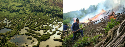
Left image contains direct link from source, right image obtained from:
http://environmentalgeography.wordpress.co
Abstract:
Over the years considerable attention has been given to understanding the subsistence strategies of the Central Lowland Maya of the Petén by scholars. Documented evidence as well as several proxy studies have concluded that the Central Lowland Maya utilized several methods of agriculture such as slash and burn, raised fields (wetland), terracing, orchard gardens and foraging [21, 26, 16]. Debates and studies argue for what agricultural methods were utilized as a main source of subsistence.
However, little attention has been given to the compatibility of agricultural methods on the surrounding environments. We will evaluate the impacts of two forms of agriculture: slash and burn (also known as swidden or shifting agriculture) and wetland agriculture (also known as floodwater, or ridged field farming), as used by the Central Lowland Maya. "Slash and burn agriculture is sometimes described as non-sustainable and is a primary cause of tropical deforestation." [15]. On the other hand, intensive wetland agriculture of Mesoamerica is characterized as a “productive and sustainable agro ecosystem” [18].
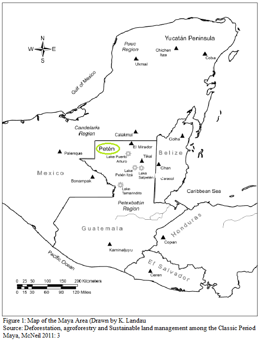
Introduction to the Petén Region of the Yucatan Peninsula
(Fig. 1: Map of the Petén south Yucatan Peninsula, western Belize, southeast Guatemala, east Mexico, and northern Honduras [see pic for reference source])
|
Topography:By understanding the topography and temporal climate of the Petén (which overlays over three modern day regions: Belize, Yucatan, Mexico and Guatemala) we can begin to understand how the environment is impacted as well as the extent to the use of successful agriculture over a long period of time.
In the Central Lowlands of the Petén the average annual rainfall is approximately 2000 mm/year. There are pockets of dense forest as well as a variety of wetland systems. Most of these areas overlap in environmental conditions and differ especially in precipitation levels and rainfall. In northern Yucatan, for example, the average yearly rainfall varies as much as 1150 mm/year within a distance of 500 km [22]. Throughout the Central Lowlands of the Petén region there are a number of fresh and saline bodies of waters (aquifers, cenotes, rivers, and lakes), the average sea levels also vary approximately between 10-300 m/asl (Markyral 2000: 91). The Yucatan peninsula and the Petén re composed on a limestone platform, which in conjunction with its different types of water sources, is characterized as having a karstic topography. |
So what does the topography tell us about the Petén Region?
The varying temporal climate and landscapes found throughout the Petén tells us that the conditions are highly seasonal and influenced by wet and dry conditions.
What needs to be considered in this type of terrain are the impacts of agricultural activity that influence changes within the tropical cycle of soil nutrients and precipitation distribution.
What needs to be considered in this type of terrain are the impacts of agricultural activity that influence changes within the tropical cycle of soil nutrients and precipitation distribution.
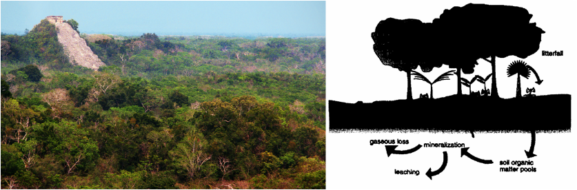
Photo (left) Obtained from Weebly Free Photos
Figure 2: Model of Nutrient Distribution
Source: Soil Biological in Slash and Burn Agriculture, Palm et al. 1996
Note: This caption demonstrates a cycle of nutrient distribution. The same inference can be made with percipitation found further in our research.
